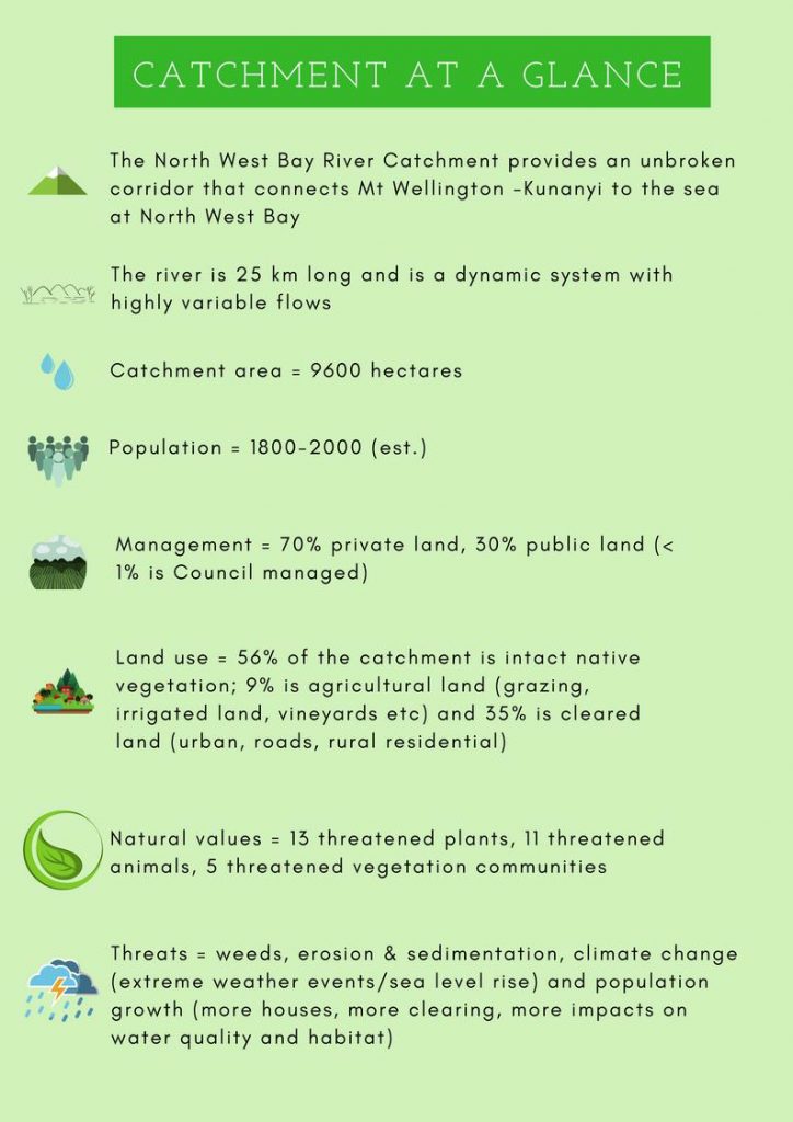
The North West Bay River is the largest river system in the Kingborough Municipality with a catchment area of approximately 9,600 hectares.
The Catchment incorporates a large proportion of the southern slopes of kunanyi/Mount Wellington. The river flows through Wellington Park, into a semi-rural landscape in the mid-catchment until it meets the estuarine mudflats of North West Bay at Margate.
Approximately 70% of the Catchment is private land, Wellington Park Management Trust controls 25.9% and Kingborough Council owns a series of linear riparian reserves which make up less than 1% of the total catchment area.
To ensure the management of the catchment preserved the natural and social values of the area, a catchment plan was developed by Council with community and stakeholders involvement in 1999.
In November 2021, Council approved an updated Management and Action Plan which details an assessment of the catchment and a range of actions and projects to improve the resilience of the Catchment.
The updated Plan found that whilst the natural conditions of the catchment area are relatively stable, threats from weeds, vegetation clearance and the effects of climate change are present.
The key action of this plan is to re-engage and empower the community and key government stakeholders in the management of their land for the benefit of the wider catchment.
Maintaining the resilience of the catchment is imperative in the face of future challenges such as climate change and population growth.
What can you do to support catchment health?
- Manage weeds on your property
- Maintain onsite wastewater management systems to help improved water quality
- Prevent stock access to waterways
- Rehabilitate eroded areas; revegetate cleared land adjacent to waterways
- Manage pets to minimise impact on native wildlife
Get involved! Keep an eye out for local events, working bees and opportunities to learn more about the river and support restoration and monitoring work. Interested in finding out more, please contact the Natural Areas and Biodiversity Team on 6211 8200.